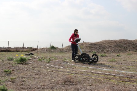
Image of the archaeological site of Dromolaxia - Vizakia (Hala Sultan Tekke), Magnetic Gradiometer System

General Information
Collection of digital resources of Dromolaxia - Vizakia (Hala Sultan Tekke) archaeological excavationThe Cyprus Institute - STARC, Department of Antiquities of Cyprus, Mediterranean Archaeological Research Institute-Vrije Universiteit Brussel
The Cyprus Institute - STARC
EN
Cyprus
Late Cypriot Bronze Age
2014-10-15
This image shows the archaeological site of Dromolaxia - Vizakia (Hala Sultan Tekke) in Larnaca. More specifically the picture depicts a member of the STARC team using the Magnetic Gradiometer System during the geophysical survey that took place at the excavation site (Building C, Area 8) in January 2014. The Grad601 is a vertical component fluxgate gradiometer, comprising a data logger, battery cassette and has two Grad-01-1000L cylindrical sensors mounted on a rigid carrying bar. Each sensor contains two fluxgate magnetometers with one metre vertical separation. Adjustments to remove the small residual errors are made automatically, requiring the operator only to rotate the gradiometer in response to instructions from the Data Logger. Calibration of the gradiometer is by simple push-button control, eliminating the uncertainties usually associated with mechanically adjusted instruments. The instrument operates in either survey or scanning mode. In survey mode, data is logged using continuous or single-shot measurements, while covering the site in parallel or zigzag paths. In scanning mode, the instrument operates as a search tool with an adjustable audio alarm, without logging data. Either mode can be used to locate archaeological features, pipes, cables, waste drums and unexploded ordnance. Survey data are saved in grids of 10, 20, 30 or 40 m².
Cultural heritage asset »
The Cyprus Institute - STARC
Cyprus
The Cyprus Institute - STARC, Department of Antiquities of Cyprus, Mediterranean Archaeological Research Institute-Vrije Universiteit Brussel
Image of the archaeological site of Dromolaxia - Vizakia (Hala Sultan Tekke), Magnetic Gradiometer System
A Late Cypriot Bronze Age town is situated in a field west of the mosque of Hala Sultan Tekke and the Larnaca Salt Lake. The town extends about 600 x 400 m (240 000 sqm). A street, 4-5 m wide, runs through the town in a north to south direction. The house complexes often consist of a courtyard surrounded by rooms and in front of the entrances to the houses there is often a paved platform, raised above the level of the street like the passage ways of Pompeii. The houses were either used as workshops or for living and commercial activities. Three bathrooms with ashlar floors have been discovered. A large building with interior supports for pillars and an inner room may probably be identified as a sanctuary. The oldest remains of a settlement date back to the Middle Cypriote Bronze Age or c. 1600 B.C. The town was destroyed in c. 1190 B.C. and again in 1175 B.C and ceased to appear in the 11th century B.C. The site underwent a short revival in the Hellenistic period.
Late Cypriot Bronze Age
IMAGE
Dromolaxia - Vizakia (Hala Sultan Tekke), Larnaca, Cyprus
Larnaca, Cyprus
WGS84
34.886370
33.604243
Dromolaxia - Vizakia (Hala Sultan Tekke)
8
C
The Cyprus Institute - STARC, Department of Antiquities of Cyprus, Mediterranean Archaeological Research Institute-Vrije Universiteit Brussel
Digital resource provenance data »
Canon EOS 6D
058024016641
Tamron SP AF 28-75mm f/2.8 XR Di LD Aspherical (IF) Lens
0580240166645655
f/11
IrfanView 4.32
35 mm
1/200 sec
Kyriaki Yiakoupi
The Cyprus Institute - STARC
058024016641
Tamron SP AF 28-75mm f/2.8 XR Di LD Aspherical (IF) Lens
0580240166645655
f/11
IrfanView 4.32
35 mm
1/200 sec
Kyriaki Yiakoupi
The Cyprus Institute - STARC
Digital resource »
The Cyprus Institute - STARC
Cyprus
The Cyprus Institute - STARC, Department of Antiquities of Cyprus, Mediterranean Archaeological Research Institute-Vrije Universiteit Brussel
Image of the archaeological site of Dromolaxia - Vizakia (Hala Sultan Tekke), Magnetic Gradiometer System
Archaeological area
JPG
4.44 MB
Dromolaxia - Vizakia (Hala Sultan Tekke), Larnaca, Cyprus
Late Cypriot Bronze Age
IMAGE
3456
2304
72 dpi

