The church of Ayia Marina in Dherinia, setting up the equipment
General Information
Collection of digital resources of the church of Ayia Marina in DheriniaThe Cyprus Institute - STARC, Department of Antiquities (Cyprus), United Nations Peacekeeping Force in Cyprus (UNFICYP)
The Cyprus Institute - STARC
EN
Cyprus
12th century
2013-11-27
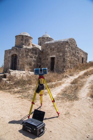
This image was taken at the site of the church of Ayia Marina, while setting up the equipment for the 3D data collection for the documentation of the architectonic components.
Cultural heritage asset »
The Cyprus Institute - STARC
Cyprus
The Cyprus Institute - STARC, Department of Antiquities (Cyprus), United Nations Peacekeeping Force in Cyprus (UNFICYP)
The church of Ayia Marina in Dherinia, setting up the equipment
The church of Ayia Marina was built on top of a small cave, located ca. 2 kilometres east of Dherinia village, Ammochostos, on the eastern shore of a local stream, within nowadays a barren and abandoned area. There are only dirt roads to access the site and at the location of the church there is no running water or electricity. According to Victor Karagiannis (Καραγιάννης, 2012), the church was built in the 12th century and it is one of the oldest ones located within the Ammochostos (Famagusta) region. Originally, the church was a single – domed chapel without a narthex. Later, probably during the 14th century, the chapel was expanded in two phases. Based on later architectonic elements, as well as traces of ruins in the northern part of the church, the church was highly prospered during the 14th century. Still, there is no identification of when or why it was eventually abandoned. Today the church is not accessible by the public as it is located within the United Nations patrolled area Nevertheless, once a year, when it is the celebration of the name day of Ayia Marina, United Nations officers escort the public to the church for a visit. However, this restriction of access to the region tend to destroy both the church and its surrounding landscape since the Five Arches (part of the medieval aqueduct) and several artefacts related to the church are lost in the plants of the streams.
12th century
Church
perimeter
35.5
meters
area
70
square meters
volume
200
cubic meters
Dherinia, Ammochostos, Cyprus
Ammochostos District, Cyprus
35.06667
33.95833
Cyprus
Καραγιάννης Β., 2012, Εκκλησία Αγίας Μαρίνας, Δήμος Δερύνειας [Online]. Available at: http://www.deryneia.org.cy/el/episkeptes/ekklisies/agia-marina. [Accessed: 08-Jul-2013]
Cyprus
The Cyprus Institute - STARC, Department of Antiquities (Cyprus), United Nations Peacekeeping Force in Cyprus (UNFICYP)
The church of Ayia Marina in Dherinia, setting up the equipment
The church of Ayia Marina was built on top of a small cave, located ca. 2 kilometres east of Dherinia village, Ammochostos, on the eastern shore of a local stream, within nowadays a barren and abandoned area. There are only dirt roads to access the site and at the location of the church there is no running water or electricity. According to Victor Karagiannis (Καραγιάννης, 2012), the church was built in the 12th century and it is one of the oldest ones located within the Ammochostos (Famagusta) region. Originally, the church was a single – domed chapel without a narthex. Later, probably during the 14th century, the chapel was expanded in two phases. Based on later architectonic elements, as well as traces of ruins in the northern part of the church, the church was highly prospered during the 14th century. Still, there is no identification of when or why it was eventually abandoned. Today the church is not accessible by the public as it is located within the United Nations patrolled area Nevertheless, once a year, when it is the celebration of the name day of Ayia Marina, United Nations officers escort the public to the church for a visit. However, this restriction of access to the region tend to destroy both the church and its surrounding landscape since the Five Arches (part of the medieval aqueduct) and several artefacts related to the church are lost in the plants of the streams.
12th century
Church
perimeter
35.5
meters
area
70
square meters
volume
200
cubic meters
Dherinia, Ammochostos, Cyprus
Ammochostos District, Cyprus
35.06667
33.95833
Cyprus
Καραγιάννης Β., 2012, Εκκλησία Αγίας Μαρίνας, Δήμος Δερύνειας [Online]. Available at: http://www.deryneia.org.cy/el/episkeptes/ekklisies/agia-marina. [Accessed: 08-Jul-2013]
Digital resource provenance data »
Canon EOS 6D
058024016641
Tamron SP AF 28-75mm f/2.8 XR Di LD Aspherical (IF) Lens
0580240166645655
f8 – f16
Adobe Photoshop Lightroom
28mm
1/40 – 11/125 sec
Kyriaki Yiakoupi
The Cyprus Institute - STARC
058024016641
Tamron SP AF 28-75mm f/2.8 XR Di LD Aspherical (IF) Lens
0580240166645655
f8 – f16
Adobe Photoshop Lightroom
28mm
1/40 – 11/125 sec
Kyriaki Yiakoupi
The Cyprus Institute - STARC
Digital resource »
The Cyprus Institute - STARC
Cyprus
The Cyprus Institute - STARC, Department of Antiquities (Cyprus), United Nations Peacekeeping Force in Cyprus (UNFICYP)
Image of the site of the church of Ayia Marina, setting up the equipment
Church
JPG
3.27 MB
Ammochostos, Cyprus
12th century
2013-30-11
10:51
Image
3648 pixels
5472 pixels
72 dpi